

(CLICK on any of the pictures in the blog to make them larger)
Each year, members of our Facebook group "I Grew Up In Daytona Beach" meet on the Saturday after Thanksgiving to take a walk. The purpose of the walk is not necessarily a docent led tour of the town, but to get out of our cars and walk through an area of town that you might THINK you know, but to see it as a pedestrian and take in the details of things you would not see driving past. We take note of the changes, how things used to be, and what will be in the future, and share stories along the way.
THIS BLOG is an accompanying text covering what we saw, and
posting historic info and pictures of what may have been there before. This is a great read for those who went on
the walk or those who missed it entirely but want to know more about the
history of the area. While my historic contexts should be correct, I do not necessarily guarantee the exact accuracy of certain dates, but share this info to the best of my knowledge in an informal vein.
After some consideration, the Silver Beach corridor made a lot of sense because of the new bridge which was completed this year...finally. It was a great opportunity to explore our investment. I thought it might be tame, but the more I thought about it, the more historic significance I found in that corridor. This led me to decide to take everyone to the Ocean Dunes neighborhood, an area I fell in love with many years ago, and learned significant historic details about that I wanted to share.
This blog may end up lengthy and very image heavy, but I will do my best to break things down into separate sections/chapters. If you see an image you wish to inspect closer, you should be able to click on it to open larger. I have broken the blog down into 8 parts:
Chapter 1 - Beginning at City Island
Chapter 2 - Courthouse Annex
Chapter 3 - Jackie Robinson Ballpark
Chapter 4 - The Island South of Orange Av
Chapter 5 - The New Bridge
Chapter 6 - The Gamble Property to Ocean Dunes
Chapter 7- Ocean Dunes and Charles Wilder
Chapter 8 - The Last Leg of the Walk
CHAPTER 1: Beginning at City Island
We met at the Courthouse Annex parking lot on the west end of the bridge, congregating while distancing before our 10 a.m. departure. We did not take time to actually walk all of City Island, as it is pretty familiar to most in it's current incarnation, but I did take a few minutes to point out how the island has evolved. It was not always that size, most of the island is man made, built up from dredge spoils from the river. Most of the land making up the park space on Beach Street is all dredge spoil as well. The water used to be right about up to the road, hence the name "Beach St.".
Historically, the corner of Orange Avenue at Beach Street, and on to the island has always had a municipal usage. The city hall, police departments, fire departments and a train depot were all located on that corner. The first public library appeared on the shore of the river at the base of where the bridge would eventually land.


As more land mass was added to the island, more thought was given to the usage of the land. As the land is deeded currently, the state has control of it, and it must be maintained for municipal use. The city HAS been quietly involved with talks in regard to paying off the state to change the deed restrictions, and allow the city to do what it likes with the land, meaning, they could liquidate parts of it to private development. There are other sections of the island that are controlled by county usage. The county is deeded the annex land and the library land, and the city holds the deed to all the rest, including the land south of Orange Avenue. There have been talks over the years of having private development on the island, as well as south of Orange Avenue on the land behind the Yacht Basin. Time will tell how that all plays out in the future, and whether or not the local residents have any say about it at all.
Back in the 60s, there were radical ideas coming in to play on several fronts. Plans were submitted to make the island a government complex, basically stretching the downtown area east of Beach St for office complexes. Another plan called the Regatta was submitted. It would have been planned and anchored by J.C. Penney with a layout of new shopping outlets, retail and office space and motels, apartments, and more. It would have been a "riverwalk" style community. Those plans and others were obviously not approved.
A takeaway observed by some was the lack of facilities...IE, restrooms. There are many things to draw you to the area...the Sweetheart Trail, the parks, the playgrounds, recreation courts, piers, and the bridge itself which was trafficked heavily by walkers and the curious. There was nowhere for them to get a drink or use the bathroom. I can see where people would be tempted to pee in bushes or try to poop under a bridge, either by emergency or for homeless or those who have nowhere to retreat to. The only facility on the island for the public is by the library, and it was padlocked on the day of our outing. I arrived at the courthouse early and thought to void my bladder before the walk, and had to drive away to look for facilities...and ended up at the Wawa on US-1. That does not seem like a great plan for an area trying to attract people to it and is something the city or county should address.
Here are some varying images of the island over the decades:


1970 dredging plan to expand the size:

CHAPTER 2 - COURTHOUSE ANNEX
The existing courthouse annex building is an iconic landmark structure in the area. It has only been there since around 1971. It was the first building of what was to be 3 identical structures, complementing other municipal buildings to appear to the north. The other buildings never appeared. The surrounding area has been used for recreational activity such as a boat house for rowing teams, tennis courts and park space.
The current annex was built to replace the aged out county offices that had been serving the area. The original site was at 2nd St and Riverside, at the Holly Hill State Market area that was for some time known as the Law Center. That was where you went for county services like the Clerk of Court, automobile tags, and more. As room there got tight, they expanded to a house on Beach Street that was donated to the county by the Rawlins family. In 1950, an annex was constructed onto the back of the house and that was used until 1971. The Rawlins house then became used for other county facilities, notably the health department. The building still stands today.
The future of the current annex is uncertain. Most theories suggest that a new county complex will appear on the lot where the current County Admin bldg is (the old Sears store). They are suggesting that complex will eliminate the need for the current annex which most people feel is not adequate for its current usage, in regard to safely transporting prisoners to court, ADA compliance, etc... If it is rendered obsolete, there is no telling what will happen to the building...if it will be scrapped, or retooled.
In the area of the annex, to the southeast, there is now a beautiful line of docks for congregating and fishing. They stretch under and around the new bridge.
There is a veterans memorial planned for the river shore area east of the annex. Time will tell if that comes to full fruition, or funding, in light of the current "new normal".


CHAPTER 3 - JACKIE ROBINSON BALL PARK
AKA...City Island Ball Park, or Radiology Associates Field...depending on your age. The ball park has been there since 1914. The grandstand and pressbox as we know them were added in 1962 after the park took a hard hit from Hurricane Donna in 1960.
One reason the stadium is named for Jackie Robinson is the fact that Daytona Beach was the first Florida city to allow Robinson to play during the 1946 season's spring training. Robinson was playing for the Triple-A Montreal Royals, who were in Florida to play an exhibition game against their parent club, the Brooklyn Dodgers. Both Jacksonville and Sanford refused to allow the game due to segregation laws. Daytona Beach permitted the game, which was played on March 17, 1946. This contributed to Robinson breaking the Major Leagues' color barrier the following year when he joined the Dodgers. The refusal by Jacksonville, previously the Dodgers' spring training home, led the team to host spring training in Daytona in 1947 and build Dodgertown in Vero Beach for the 1948 season. A statue of Robinson is now located at the south entrance to the ballpark.
CHAPTER 4 - THE ISLAND SOUTH OF ORANGE AV.
We took a walk south of Orange Avenue to have a look at the current state of the city property there. There are still docks and boats using that area.
The historic building that once housed the library before they built the current library is still standing, and being used as the home office for the Daytona Tortugas. The original library in the small building north of the bridge appeared around 1909. It had high windows installed so readers would not be distracted by folks passing by. in 1920 the library moved to the 2nd floor of the city hall building at Palmetto and Orange. In 1946 it moved to the historic building on City Island until moving into the modern facility built in 1977.
The building east of that is currently vacant. For many years it was the City Island Rec Center. The city feels that it is in disrepair and not worth preservation. Some organizations have attempted to lease it from the city or have made claims that the cost to restore the building is less than the city is claiming. The likely reality is that soon, the building will fall with little notice or fanfare. South of that is the current Chamber of Commerce HQ.
This corridor is still quite beautiful, and clearly, underutilized. The history on the land is remarkable if you think about it. All of the municipal activity since the beginning of the city.
If you would like to see the marina/library/ballpark area in it's 1960s glory, watch the episodes of Route 66 that were filmed in Daytona, as they are featured prominently. The 1961 Cesar Romero movie "We Shall Return" was also filmed here. You can find a link to the movie, and Route 66 info at our group page, on a file called TIME MACHINE. Here is a link: TIME MACHINE POST
CHAPTER 5 - THE NEW BRIDGE
Call it what you may...the Silver Beach Bridge, the Orange Av Bridge, the Memorial Bridge, Veterans Memorial Bridge...you would not be wrong. The official new name is The Tom Staed Veterans Memorial Bridge. So named, as you walk over there are stations to take a break and enjoy the view that have memorial plaques in regard to different conficts the US has been involved in. This theme also ties in with the planned Veterans Memorial Park to be on the west base of the bridge at the eastern shore of the river.
Here is the artists concept of the park area intended to connect to the pier under the bridge:

The first bridge connecting Silver Beach in Daytona Beach to Orange Avenue in Daytona appeared in 1888, just after the first bridge to cross the river appeared in Ormond at Granada in 1885. Before then, the only way to cross was by boat or ferry, clearly separating the Daytona Beach peninsula from the city of Daytona. Keep in mind, all of the area cities were separate until 1926.

The prominent residents on the eastern side saw the value in the bridge. On the SW corner of Peninsula and Silver Beach was James Gamble, of Proctor and Gamble, who built his home there about 1860. On the NW corner was Laurence Thompson living in Lillian Place built around 1884. Thompson also owned land on the west side of the river along Beach St. He had a general store in a home that still stands today, known as The Abbey, which was for sale recently. It had housed a museum for a short time and the operators were attempting to purchase the property but could not raise the funds. Thompson also owned all of the property where the Yacht Club is and donated that to them around 1896.
Seeing the need for the bridge, and no funds to build it, Daytona leaders of the day formed a corporation named Halifax River Bridge and Railway Company. Investments were returned by collection of tolls for crossing the new bridge. Storms wrecked the bridge in 1910 and 1926. In 1954 it was replaced with the concrete bridge that most of us knew and remember.
The current bridge finally opened to the public in August 2020, 4 years and two months and $46 million after it was started. The stories of delays, mistakes and the remarkable timetable will remain local legend for some time, I am sure.
BUT, all done and said, it suits the area nicely, is beautiful, and if it lasts and the quality does not diminish, should serve the area nicely for decades to come.
The old bridge from the east side looking west, pre condo. Gamble house obscured by trees.

Current views in the area of the new bridge:


CHAPTER 6 - THE GAMBLE PROPERTY and to Ocean Dunes


James Gamble was the son of the founder of Proctor and Gamble, in Cincinnati, and was an early northern snowbird to the area. He built his winter retreat at the SW corner of Peninsula and Silver Beach on land he purchased from Laurence Thompson. He was a notable area resident, and a generous philanthropist. He funded many things in the area, including Bethune Cookman College. James Gamble befriended Mary McLeod Bethune who went to the Gamble House and made her pitch on a bicycle. Gamble visited her school and was surprised to find a shack. When he asked where the school was, she pointed at her head. Gamble believed in her vision and he and Thomas White acquired and donated the first 6 acres of land she needed. He was elected president of the board of trustees of BCC, and held that title for 20 years before being named Honorary President Emeritus. He would be the largest long term contributor to the college. Gamble had an account at Lawrence Thompsons store, and Thompson had orders from Gamble that if any worthy charity cases were in need, to contribute to them at Gamble's expense.
Gamble had copious holdings in the Spruce Creek area of Port Orange as well, which he used as a rural retreat. After his death, his daughter Maude inherited his local holdings. She and her husband, Judge Alfred K. Nippert continued using the mansion as a residence. Alfred created the Snow White house at the Port Orange retreat. The Port Orange properties were donated to the city around 1999, and there has been various controvery about continued funding and accessibility to the public, and what the future would hold for that property. It is currently operating and available to tour in cooperation with the Museum of Arts and Science. The Port Orange retreat is located at 1819 Taylor Road.
Mrs Gamble passed away here in DB in 1901, but was interred in Ohio. James passed in 1932. Historically after James' death, the Gamble and Nippert families continued to have a dominant presence in the area, and nationally, socially and philanthropically.
1932:


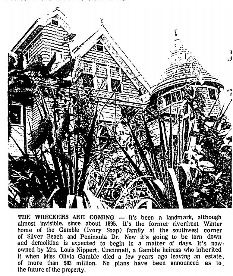
The main house was razed in 1969, leaving a couple of smaller buildings on site that were used until they ultimately fell. The land finally left the Gamble family in 1972. One of the turrets from the original house was moved to City Island to be used on the playground. If you played in City Island Playground as a kid in the 70's and remember the castle, that is where it came from.


Here is a 2015 view showing the Pendleton on the right and the Riverplace 100 Condos on the corner. This was shot from the old low bridge.
The wall surrounding the corner condo's is the same stone wall that surrounded James Gamble's house. It still looks strong and wonderful today. Here is a 2014 view:

Views from our walk:


Walking past the wall, I could not help but wonder how it survived traffic on that corner, but I guess it did have it's share of issues with cars, such as this account from 1958:


CHAPTER 7 - OCEAN DUNES and Charles Wilder
Ocean Dunes stands out as an exceptional neighborhood in Daytona Beach. When I discovered it years ago, it blew me away, and has always been impressive to those who I shared it with, so I was really happy to take the walkers there. What is as cool as the neighborhood itself is the history of how it came to be. That is thanks to Charles Wilder. Ocean Dunes is bordered by Wisteria to the north, Ocean Dunes to the South.

The Wilder family came to Daytona from Cincinnati in 1877, when C.M. (Charles) Wilder was 12 years old. (Can you see the trend of how important Ohio was to the founding of Daytona? Matthias Day, Thomas White, James Gamble...the list is long...). The Wilders bought a large chunk of the Bethune Grant, which was the land west of the river from about Shady Place to Beville Road, and extending west of the railroad tracks about 2 miles total. They were using it for various things, homesteading and citrus groves included.
The Wilder family story is long, but I will digest it here by saying that Charles returned to Ohio for schooling and had settled in there. The elder Wilder drowned in 1885 and Charles became an heir to his fathers property. He had gotten married around 1897 and started a family in Ohio. Charles felt that the area was better for the health of his children than Cincinnati, so he came here to build a Florida home for his family. He chose a plot east of his father's property, 1716 S. Peninsula Dr, which would today be on the western end of Ocean Dunes road, on the east shore of the river. That road today west of Peninsula is a cul-de-sac of very modern and large homes. I do believe part of Charles' home there still stands, but you cant see much of it from the street, and a large home has been added adjacent to it.
As a child, Charles would take a boat from his fathers land, and cut over to the other side of the river and walk to the beach. The path that he took thru the Botefuhr property at the time is still there, now called Old Trail Rd. There are stories of the kids encountering bears in there and going to the Botefuhr house to be safe.
As an adult returning to town, Charles acquired the land between his plot and the ocean, where the Ocean Dunes neighborhood is now. Charles also built a cabin on the ocean for his family to enjoy days at the beach in comfort.

In the 1920's Charles intended to develop his fathers plot on the mainland into a fantastic concept called Country Club Harbor. This concept would encompass a golf course and high end residences and commerce areas to serve them...much like Rio Vista to the north in Holly Hill. He had Frederick Law Olmstead come from Boston to lay it out. The Olmstead family are responsible for the development and layout of some of the most fantastic properties in the USA, including Central Park in NYC, keeping in mind keeping nature intact as much as possible. Olmstead was also active in 1927 trying to convince the city to preserve the trees along Ridgewood Avenue.
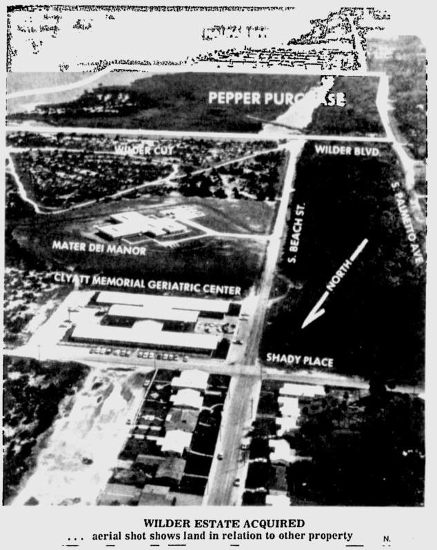
The plans were made, but the depression came and it never fully came to fruition, other than the layout of some roads and opening of the sales office to take orders for homes. The area behind Tzadik Bay apartments is still known as Wilder's Cut, and that of course is how Wilder Boulevard got named.


By 1929, the Country Club Harbor site was platted much more like we know it today:

In 1969, the Pepper's bought the tract of Wilder property from Wilder Blvd to Beville.
Land on the Peninsula was selling in bulk, and people were just scraping the land and using it for farming, or during the boom, flattening dunes and building houses in a row. This frustrated Wilder who saw the value in preservation. Taking his cues from Olmstead, he laid out the subdivision of Ocean Dunes, taking care to keep the natural topography intact whenever possible. Several of the homes built in the 1920s are still standing there today. The neighborhood is a great mix of original vintage, 1940s, and mid century homes. There is plenty to see in the heart of Ocean Dunes which is generally bordered by Wisteria to the north, and Ocean Dunes to the south.
In 1939, the Ocean Dunes Club was formed as a private corporation and operated by area residents. The corporation was dissolved in 59 and the club sold to private developers, but many still remember this facility.

The Wilder cottage on the ocean in the Ocean Dunes area...

I encourage everyone to drive or walk thru Ocean Dunes, or as a minimum, use Google maps street view and have a look around. Here are a few snapshots from our Walkabout thru that neighborhood:


CHAPTER 8 - THE LAST LEG OF THE WALK
When we got to the north end of Crescent Ridge, we decided to cut back east to A1A, in hopes of possibly finding a place where people could use the rest room or buy a drink, but we had no luck. We started to head west on Bostwick, but I checked to see if anyone wanted to cut up to the Sunoco mart at Silver Beach, but everyone was ok so far.


Bostwick is an interesting road, and there are some fantastic homes there as well, but the star of the area clearly is Gamble Place, the street, not the attraction in Port Orange, HAHA. There are well preserved beautifully landscaped homes in the area that are worthy of looking at. If you are whizzing by in a car, you cannot appreciate them properly. That is what the walkabout points out.


From Gamble Place, we returned to Silver Beach. From that area east it is not spectacular due to progress, but, there are still some great historic homes. That block could stand to be gentrified some as some of the homes are being used as apartment/rooming houses and it would be awesome to see them restored to single family homes.
The eastern end of Silver Beach back in "the day":


At Silver Beach and Peninsula, we took a slight jog to the north and walked down the driveway toward the historic Hotchkiss House and Lillian Place. On that corner, there are still several privately owned residences on the corner, bordered in by the Hotchkiss and Lillian Place which are now owned by The Heritage Preservation Trust. In times of no COVID, the Hotchkiss house is available for booking events. Tours of Lillian Place and their gift shop are indefinitely cancelled for now. They are taking advantage of that to do some remodeling and upkeep on the property, so you can see work in progress.


Lillian Place was constructed in 1884 and was the Laurence Thompson residence. The Hotchkiss house was constructed in 1905 for E.H. Hotchkiss of CT. Hotchkiss was the maker of the world famous Hotchkiss stapler, at one time the best known stapler in the world. The Japanese word for stapler is "hotchikisu".
You can visit the Heritage Trust site at this link: HERITAGE TRUST
After leaving the historic corner, we concluded our voyage by heading west over the north side of the bridge and returning to the annex.


Thanks for taking the time to read my blog. If you would like to join our Facebook group, click this link: I GREW UP IN DAYTONA BEACH FACEBOOK GROUP .
The info offered here is considered to be generally correct to the best of my knowledge. If you see any glaring errors, have any comments or just want to say hi, shoot me a message here or you can visit my website at www.harryoke.com where all of my contact info is posted.
At the Facebook group you can also find the Time Machine file linked, that has links to other area videos, and blogs from past Walkabouts. Here is a link: TIME MACHINE.
Until next year...stay safe, and will see you online! If you have any requests or suggestions for the 2021 walk just let me know.
Harry
