 |
| 2018 Walkabout area, showing Manatee Island, the Broadway jut, and more detail about areas described in the blog below. |

Each year, members of our Facebook group "I Grew Up In Daytona Beach" meet on the Saturday after Thanksgiving to take a walk. The purpose of the walk is not necessarily a docent led tour of the town, but to get out of our cars and walk through an area of town that you might THINK you know, but to see it as a pedestrian and take in the details of things you would not see driving past. We take note of the changes, how things used to be, and what will be in the future, and share stories along the way.
THIS BLOG is an accompanying text covering what we saw, and posting historic info and pictures of what may have been there before. This is a great read for those who went on the walk or those who missed it entirely but want to know more about the history of the area.
This year we explored the North Beach street area, loosely bordered by Michigan St to the north, the intercoastal to the east, Bay St to the south and Ridgewood to the west. This was one of the shorter walkabouts we have done, but it was dense in content. Our timing was really good, because in another year, there will be many changes. Much of what we saw on our walk will either be improved, or removed. The new Brown and Brown complex coming will anchor the north end and create more change to follow by other property owners. There will also be changes at the County Admin bldg currently closed due to mold issues following the storm damage from hurricanes. A new complex should be built on that site and the old one razed as well.

Enjoy these pictures from our walk, along with some associated history. My information is correct as far as I know, but I do not guarantee that my info is 100% historically accurate. I am not a professional historian, I simply play one on the internet.
CHAPTER 1: History
CHAPTER 2: Start - Rogers Info
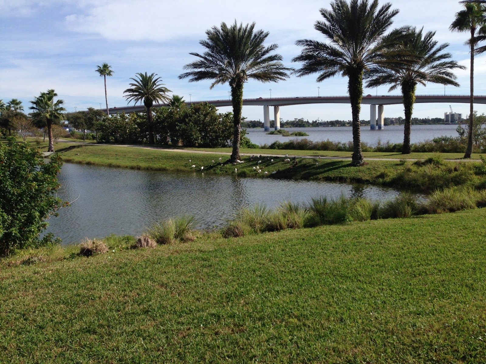
CHAPTER 3: Manatee Island
CHAPTER 4: NJ Center / Broadway Bridge
CHAPTER 5: Bay / Canal / Post Office / Sears
CHAPTER 6: San Juan Area at Beach St
CHAPTER 7: Palmetto to Bay to Ridgewood
CHAPTER 8: San Juan area Neighborhood
CHAPTER ONE: HISTORY
The Daytona area for the most part was settled in the 1800's after Spanish land grants put real estate in the hands of speculators. These founding families generally divided their parcels up for development, and worked to create an infrastructure which still largely shapes the development of the area to this day. There were no bridges from the mainland to the beach side, so each area became its own community. Eventually, with progress, the communities joined forces and incorporated as the city we know today. Back in the 1800's, up to the early 1900's, the North Beach Street area was largely residential, with most of the commercial ventures a little further south to Orange avenue and south of there. The commercial development crept north, eventually taking over the homes and basic wilderness that was there up to that point.

 |
| Adding land mass following dredging |

 |
| Tract showing land in the Fairview area to north |
 |
| Tract showing the Fairview and riverfront corridors and who had the land platted |
Beach Street has pretty much always been in the same location, BUT, the park as we know it did not exist. Along Beach Street for the most part was a simple shore. In later years a seawall was built along Beach Street. As dredging in the intercoastal occurred, the spoils were placed by the shore, extending the land into the park areas we know now, including City Island. Much land area along the coast was created in a similar fashion.


As development happened, residences were built nearby and the town grew from east to west. In the early days of the city, most of the residents lived in the quaint neighborhoods between downtown and Ridgewood avenue, and points just west of there. Many of the grand homes along the Ridgewood corridor are gone, making way for the the wider highway, progress, and the businesses that have taken their place. Some of the simpler homes fell victim to abuse over the years, and to neighborhoods that became blighted, and no longer exist. There are still PLENTY of really great historic homes and buildings in all manner of condition in the area if you look around closely.
In the early 1900s, there was even rail/trolley service serving the downtown area.
 |
| North Beach Street |
 |
| 1915 - Info about the history of the trolleys, from the Edwards Collection |
CHAPTER TWO: STARTING POINT: Rogers House and Rogers Family Info

There is a house currently in the park at 355 N Beach St that was the former home to David D. Rogers, one of the founders of the area. It was later home to his daughter, Josie, who was not only the first female doctor in the area, but also the first female mayor of Daytona in 1922. She was only the second female mayor in the entire state at that point.

The home was built on the riverfront around 1878 by her father, land surveyor David Dunham Rogers, the house doubled as Josie Rogers' medical office where she treated both black and white patients in the early 1900s.
Josie Rogers was a physician at the Halifax District Hospital, known today as the Halifax Medical Center, and was named chief of staff in 1947. She became Daytona Beach's first and only female mayor in 1922.
As a woman doctor and as a woman politician, she was a very important historical figure from this area. Unmarried and without children, Rogers died in 1975 when she was 98 years old.

Josie standing alongside the families Maxwell, on the Riverfront, 1909
 |
| 1909 |

 |
| Rogers House in background |

Here is a pic of another Rogers family members home downtown, at the corner of Beach and Magnolia.

Many know this by other names, but the official name for the island is Manatee Island. It is currently set up as a city owned park. The Rogers house on the mainland greets you, and then a pedestrian bridge over the intercoastal takes you to the island, where the amenities include playgrounds, pavilions for get togethers, bathroom facilities, docks and a huge open air amphitheater that would be fantastic for music or theatrical events. Most residents of the area have never been to this part of town unless they attended an event there such as the annual Oyster Festival. While this had become a haven for the homeless, that issue seems to have been resolved with strict enforcement by the local police, and locking the gates after hours. (google MANATEE ISLAND DAYTONA to see articles about issues on the island...) While we were there, we saw ZERO issues of concern on the island. It was actually very nice taking in the views along the shore, and admiring the updated amenities. Only negatives were the damaged docks that remained in disrepair since the hurricanes, and the fact that the lovely amphitheater sits there unused, largely ignored by the residents who don't know about it. That is a shame!
 |
| 1961 Manatee Island aerial |


CHAPTER 4: NEWS JOURNAL CENTER (and the death of the Davidson owned News-Journal) :

The News Journal Center is situated just south of the Rogers home at 221 N Beach Street. It is operated by Daytona State College, and has no affiliation with the News Journal, other than naming rights.
(From Wikipedia) In January 2003, the News-Journal offered to pay $13 million for naming rights to a new performing arts center in Daytona Beach being built as a new home for the Seaside Music Theater, founded by News-Journal CEO Tippen Davidson. Cox Enterprises filed suit against the News-Journal Corp. (NJC) in U.S. Federal Court, alleging they "acted irresponsibly in spending corporate funds". Cox alleged that the Davidson family spent the newspaper's money without consulting with them.
Court documents reveal that in the five-year period prior to the filing of Cox's complaint, at least 58 employees of Davidson's arts and entertainment ventures were on the News-Journal Corp. payroll, unbeknownst to NJC's sole minority shareholder. Despite the fact that these employees did no work for NJC, the corporation provided them with full salaries and benefits, at a cost to the company of at least $5.7 million. The trial court found that tens of millions of dollars were diverted to Davidson family projects to "indulge [the Davidsons'] personal interests in the arts".
After failing to have the suit dismissed, the News-Journal Corp. decided to exercise its option to buy out the minority shares. In 2006, the federal court set a valuation of $129.2 million on Cox's interest in the paper. Newspaper management announced in April 2008 that the newspaper would be sold in order to satisfy the judgment. On April 17, 2009, the News-Journal announced its intention to declare bankruptcy, but the judge overseeing the case rejected that option. The board of directors was subsequently removed and the company was placed under court control, with James Hopson serving as the court-appointed manager.
 |
| Rear view of center, from river |

 |
| the southern entrance with naming rights by the speedway |
 |
| The land jutting out into the intercoastal that was the old Broadway Bridge ramp. New ISB in background |
The NJ Center sits just north of the land that was the landing for the original Broadway Bridge. The Broadway Bridge was the first concrete bridge in the area, and and ran from Broadway on the beach side, to dead end at Beach Street in front of the current Post Office area. In later years, the ramp was realigned several times, with the landing remaining at the park, but with access ramps to align the roads with other west bound roads. In the early days, you dead ended at Beach and had to turn on Beach to access other roads. Along the access ramps were extra parking spaces for downtown employees and shoppers. After the ramps were added, you could either veer left to Volusia Av, or right to Second Av (Mary McLeod Bethune Blvd today). When the new modern ISB bridge was constructed, all the ramp area was converted back to park space.
 |
| 1925 Concrete Bridge, Before Post Office |

 |
| 1950s alignment |
 |
| 1961 |
 |
 |
| 1974 Second Ave Ramp from bridge, with parking |
Our next leg of the walk took us across Beach Street at Bay. Back at the turn of the century, this was still a very dense area. There was a canal that ran from the intercoastal at Bay, called the Spanish Canal. It flowed west thru the city. Remnants of it are still visible on maps today, and it was part of the variable that shaped development around it. The Spanish Canal was a bit of an attraction, appearing on Post Cards along with the bridge on Beach Street that passed over the canal.
 |
| 1899 Spanish Canal at Beach and Bay |
 |
| Beach at Bay 1911 |
 |
| 1926 Aerial of the area, showing canal and other detail |
 |
| More modern bridge over the canal |
 |
| old Spanish Canal bridge |
Heading back north, the historic post office sits. It was constructed in the 30's. At that time, the area was still dense with homes and hotels/boarding houses. The site of the post office was previously a meeting place (casino...not gambling) which can be seen in the 1925 pic posted of the Broadway bridge ramp, above. Here are some rare shots of the Post Office under construction.


 |
| The grave of the second "Brownie" located in the alley next to the north wall of the post office. The "real" Brownie who passed in 1955 is buried at Orange and Beach in the park, but this second Brownie that passed in 1970, less known, rests here. |
Beyond the post office, to the north, is the huge bank building, currently sitting vacant. Before the bank was there, it was home to a hotel, with residences behind it. In later years, the bank bought the homes behind it for parking space.
This is the structure that sat where the current bank bldg is at 3rd and Beach SW
 |
| The Austin, SW corner of 3rd and Beach |
Hobbs Home behind it

3rd Av and Beach

Some have wondered out loud why the County does not use the bank building for a new admin facility, but, there is no telling what is going on in the walls of that bldg either, and it just may be more cost effective to build a new one.
Crossing 3rd Ave to the County Administration Bldg, which is the old Sears location to many, though not the first Sears in Daytona. There were a couple of other locations, including one on Beach a few doors south. Before Sears on that corner, there was the Prince George:
 |
| Prince George, 1910 Beach and 3rd |
 |
| Prince George from Intercoastal, showing seawall |
 |
| Sears 1925 more south |
 |
| Sears 1955 1955   |
 |
| YMCA in the Sears Parking Lot |
 |
| Sears 1965 expansion plans, showing YMCA and other structure |


Change is coming to the Sears bldg as well, as it is sick and abandoned due to mold issues caused by hurricane damage. There is a proposal to build a new complex just NW of the current building and then demolish the old structure.

This plan has not been finalized, but with the progress at the Brown complex it will not take long to see a change coming soon.
CHAPTER 6: THE SAN JUAN AREA
San Juan refers to the name of a street that cut through the area just north of Second Avenue (MMBethune). A remnant of the street exists running east from LaRoches on Ridgewood to Wisconsin Av. The remaining section to Beach Street will no longer be there as it will fall on the new Brown and Brown property. Brown purchased all of the old abandoned car lot properties that sat from Mary McLeod Bethune, to the First Ave area, bordered by Wisconsin and Beach St. All of the land where the car lots were has been razed, cleared and fenced already. Brown has been aquiring the residences on the perimeter as well, and there are track hoes on site currently demolishing those houses in preparation for the new complex coming.


 |
| 1961 |


 |
| 1934 |
 |
| Roof collapsed after storm in 1936 |

 |
| Schmidts Villa, 2nd and Beach NW |
 |
| Massey, long term tenant of Beach and 2nd NW |
 |
| San Juan Motors at Beach and Second |
That area of San Juan and Beach was home to many of the area car dealers over the years, including Ray Hunt Ford, Sunrise Olds/Toyota and all of the Lloyd lines since the 1930, including Buick, Cadillac, Opel and others. As the car lots started moving west, most of the dealers followed. Lloyd was the last hold out. The car lot properties sat derelict for some time after that, leaving a blight downtown that was the point of much controversy over the years.
Just west of Beach Street on MMB, since 1898 has been the Lyndhurst.


CHAPTER 7 PALMETTO TO BAY TO RIDGEWOOD
 |
| Villas between MMB and Wisconsin, surely to be demolished |

 |
| Votran transportation hub downtown |
 |
| Office buildings between Palmetto and Ridgewood |
 |
| Back of the old Sears/county complex from Palmetto |

 |
| First Baptist location, missing Methodist church... |
 |
| earlier in 2018, demolishing the mosaic |

 |
| Bay St 1900 |
 |
| The old MHS campus from Bay to 3rd |
 |
| Bay at Beach St |
 |
| Late 1800s, The shore at Bay St, eastern mouth of Spanish Canal |
 |
| Bay St |
 |
| Hoene Park, NW Corner of Ridgewood and Bay St |
 |
| Mainland High, circa 1918 |
 |
| Existing house on Bay behind old Gulf, believed possible moved to this location from there. |
 |
| 2017 SE Corner Bay and Ridgewood before demolition |
 |
| The SE corner of Bay and Ridgewood, cleared recently |
 |
| NE corner of Bay and Ridgewood, the old Gulf Station. |
 |
| The old Gulf station in the 80s or 90s selling custom cars |
 |
| Bay and Ridgewood looking north from the east corner, showing Gulf and IBEW bldg. |
 |
| Haine Manor at 140 N Ridgewood, just south of Bay on west side where bank is now, demolished in 63 |
 |
| 1963 Demo of the Haine making way for the new Bank |
 |
| 1921, the OAKS on the NE corner of Bay and Ridgewood, where Morrisons went, now Family Dollar. |
 |
| The front of the old IBEW bldg, which used to house Channel 2, Streeps, and other businesses. Currently owned by the DB Housing Authority. |
 |
| This is the St Ives Inn, which sat where the IBEW bldg is now. |


 |
| Old gas station/garage at 2nd and Ridgewood...(MMB) |
 |
| NE Corner of Ridgewood and Second, 1900 (where gas station is now) |
 |
| San Juan at Ridgewood |
CHAPTER 8: THE NEIGHBORHOODS IN SAN JUAN AREA
The houses east of Ridgewood and west of Wisconsin are surviving, and to some extent still being used as family housing. The homes on Wisconsin and just west of that are marked for demolition, but many examples here are doing great, and will likely rise in value. This is a prime area for possible gentrification if progress continues downtown, and area housing becomes in demand as amenities increase in the downtown area to serve the new workers, and new residents of the area. Our walk took us EAST on San Juan to Wisconsin, along Wisconsin bordering the Brown construction, to First AV, then back west to Ridgewood, then east to Mulally (formerly known as Cypress St). Back in the old days Cypress connected thru, but after the roads were realigned, Cypress connected to Fairview, and was all renamed George Engram. This leg of Cypress was named Mulally after Fr. Mulally of St. Pauls Church. We then walked Mulally to Daytona Street, and took Daytona north to Michigan, and Michigan east back to N Beach St.
San Juan (the homes with V marked on them are VACANT and likely scheduled for demolition:


Along Wisconsin (all being demolished as you read this):


FIRST AVE


Mulally St... (formerly Cypress)


DAYTONA STREET


MICHIGAN

NORTH BEACH


 |
| 1962 N Beach at Michigan |
CONCLUSION:
Thanks for reading along, and thanks to those who chose to walk along this year. If you have any questions, corrections, or comments, just let me know. I am sure I have much more info I could add, and pics to add, but this is probably pretty comprehensive for now. I just really wanted to document a bit about this area before all the changes happen in the next year, and hopefully enlighten some of you about things from the past you may not have known. We do this every day at the Facebook group. I will post a link below to the group, and come join if you like. There are thousands of pics in the archives of the group, and the original first group. Thanks to those of you who share my love of local history, and follow along at the group, and HUGE thanks to those who participate, and contribute content and research to the group. We could not exist without YOU. Look thru those shoeboxes and dresser drawers, and pull out those pics of historic significance! If you ever need any assistance with that, let me know.
THE FACEBOOK GROUP IGUIDB
Photo Album at IGUIDB, with member comments and additions
- Harry Smith, admin/I Grew Up In Daytona Facebook Page
My contact info is at my business website: www.harryoke.com
Harryoke Web Site
EMAIL ME
Click HERE to view the 2017 Walkabout Blog - Town of Seabreeze
